Mt Leura & Mt Sugarloaf Reserves
Encompassing approximately 50 hectares, the Mount Leura and Mount Sugarloaf reserves are noted for their outstanding view over the Western District, their impressive form and geological and historical values.
The Camperdown district was originally inhabited by indigenous people of the Leehuura gundidj language group, who reportedly named Mt Sugarloaf ‘Tuunumbee Heear’ or ‘moving moving woman’. Mt Leura and Mt Sugarloaf were used by the Leehura people as signaling towers and lookouts to observe the movements of game and neighbouring peoples. The mounts were also important landmarks and were used as a guide for the Leehura’s semi-nomadic lifestyle.
The arrival of the first colonial settlers resulted in the sharp decline of the local indigenous population through loss of land, lack of access to food, and disease. It is a brutal fact that much of Corangamite’s early agriculture drove the First Peoples from their lands and resulted in violence and conflict. The need to acknowledge and reflect on our history is part of a more meaningful reconciliation effort.
Pioneers settled vast tracts of land within the district for sheep grazing in the early 1800s. In 1839, the Manifolds settled on the banks of Lake Purrumbete and took possession of 32,000 hectares of land which included Mt Leura and Mt Sugarloaf. The family gifted the Mt Leura Reserve to the Shire of Hampden in January 1899, while Mt Sugarloaf passed into the ownership of another private landholder.
The Mt Leura Reserve became the property of the Town of Camperdown Council when the municipality was established in 1953, and was transferred to the Corangamite Shire following amalgamation in 1995. Grazing was excluded in the 1960s and the reserve has been managed as public open space since then.
The Mt Sugarloaf Reserve was historically used for grazing and quarrying and was privately owned until the National Trust of Australia (Victoria) purchased the property in 1972 following community concern about quarrying on the western slope of Mt Sugarloaf. The reserve was subsequently leased out for grazing until Corangamite Shire Council took over the lease in 1996 and ceased grazing on the reserve in 2005.
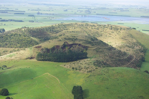
The reserves include a relatively recent extinct volcano (Mt Leura) and a remarkable example of a scoria cone (Mt Sugarloaf). Formed by gravel-sized fragments of lava approximately 22,000 years ago, the two mountains are nestled on the north-western edge of a 1 km wide, much older crater - the Leura Nested Maar. Spectacular views of the reserves and the surrounding district are offered from both peaks via a public road and car park (Mt Leura) and a walking track (Mt Sugarloaf). Owned by the National Trust, Mt Sugarloaf is managed in conjunction with Mount Leura by a Community Asset Committee.
The Committee aims to revegetate the two reserves with indigenous flora in a manner reflecting the open woodland vegetation communities existing at the time of European settlement and to provide facilities to enable visitors to more fully experience the unique volcanic environment.
Mt Leura & Mt Sugarloaf Management Plan
Location
Mt Leura Road, Camperdown 3260 View Map
-38.2427417,143.15609
Mt Leura Road ,
Camperdown 3260
Mt Leura Road ,
Camperdown 3260
Mt Leura & Mt Sugarloaf Reserves
Photo Gallery